What is the Pacific Northwest? And where is it?
The Pacific Northwest, geographically referred to as Cascadia, is the northwest region of North America, and is bound by the Pacific Ocean. It encompasses all of Washington, Oregon States and Northern California, British Columbia Canada, and Alaska. It is an area of vast beauty. Here you will find multiple climates and topography, from the highest mountains on the continent, to many thousands of miles of coastline, and globally rare inland seas.
 |
Into boats?
Into boats? I am. Here is a link to boats that I have owned, chartered, and crewed on.
 Puget Sound – Sailing out of Shilshole |
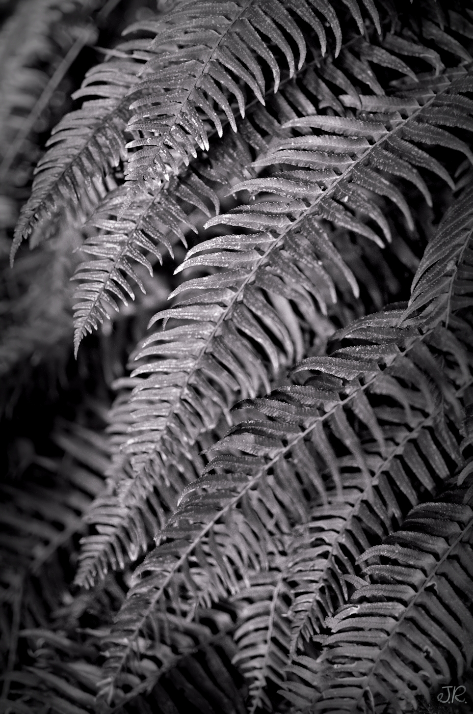
Pacific Northwest Sword Fern
This is the sword fern, the most common fern in the Pacific Northwest.
Sword Fern
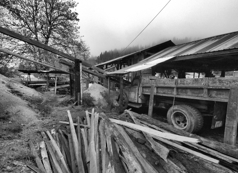
Isaakson’s Sawmill, Redmond, Washington
Isaakson’s Sawmill
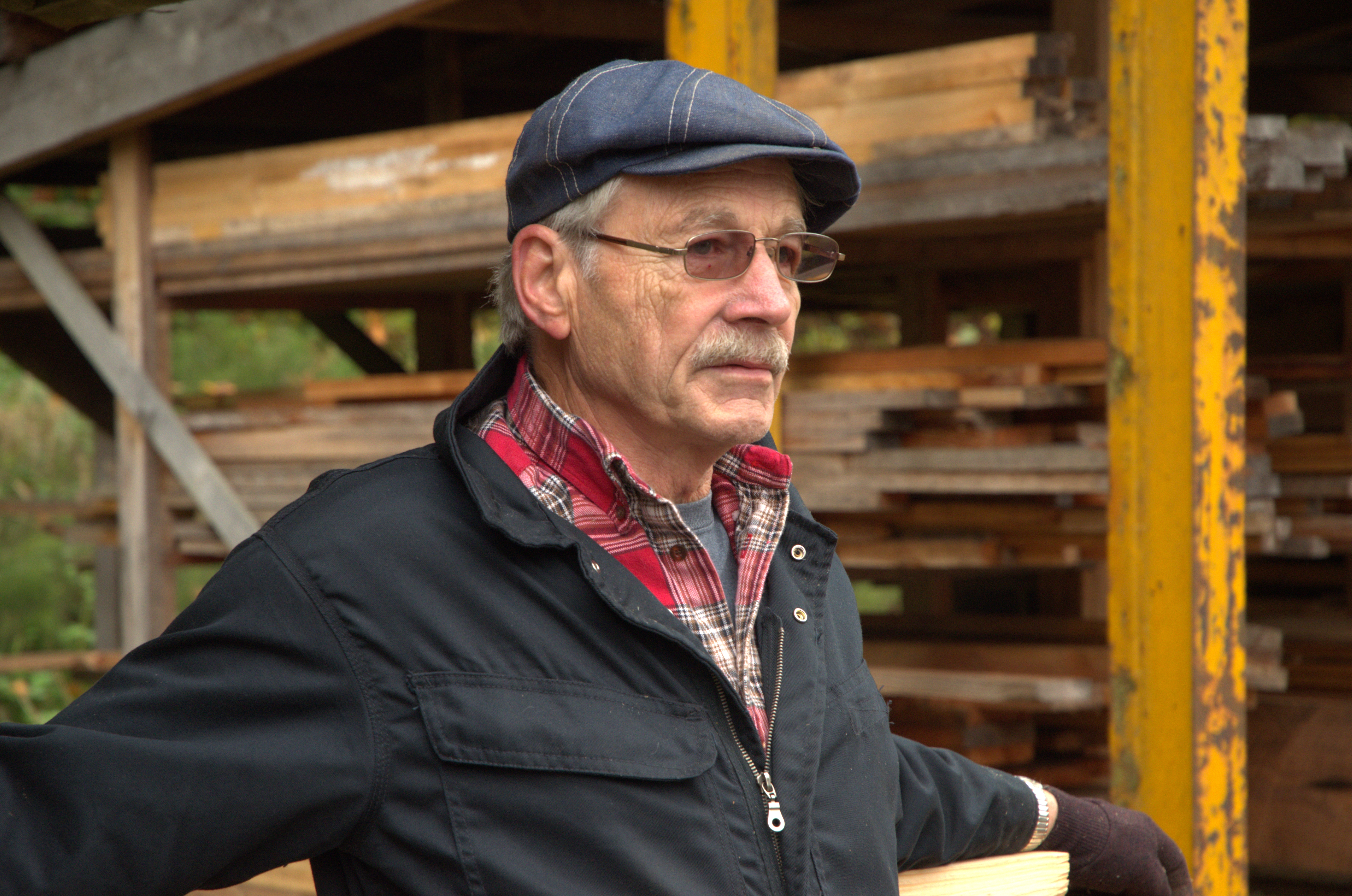
Duane Isaakson, Isaakson’s Sawmill Owner-Operator
October 19th, 2013 – In unincorporated King County, eight miles east of Redmond, Washington, along State Route 202 (Redmond-Fall City Road) there exists a sawmill that has been in existence at this location since 1936. This sawmill was established by Henry Isaacson, a log truck driver, businessman, and opportunist. Isaakson’s mill is still in operation today, owned and operated by his son, Duane Isaakson. Duane lives on his father’s original estate above the mill with his wife Joanne. You can often see smoke coming out of the stacks at the mill when driving by on 202.
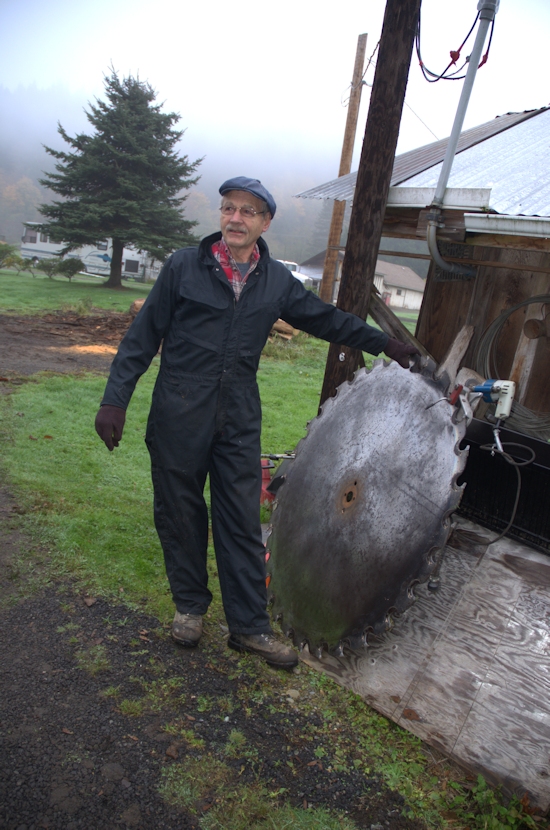
Duane Isaakson with Sawblade
Isaakson’s Sawmill was established in the 1930’s. It thrived during World War II as larger mills were tied up with the war effort. Commerce still went on for local people wanting to build homes so upon Isaakson’s Sawmill they relied for lumber. During this period locals burned sawdust from the mill as a substitute for oil and coal which were hard to obtain and very expensive if these commodities were even available.
Isaakson’s mill expanded after another area mill burned in a fire, and a planer was salvaged by Isaacson from the destroyed mill. This planer was one of the larger ones in the area. It gave them the capability to smooth and cut grooves into lumber thereby refining their lumber further for building quality.
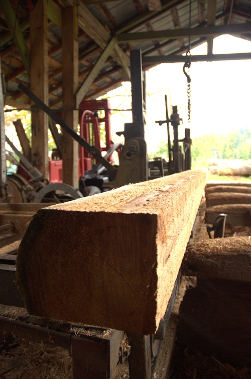
Isaakson’ Sawmill Lumber Milling
This last weekend I, with several other members of a local church, toured Isaakson’s Sawmill with Duane Isaakson as host. Duane, in his 70’s, not only enriched us with his knowledge of area history and specific history about his now deceased fathers’ mill, but he surprised us by firing up the diesels and began milling logs during our tour. He cut a log into lumber and milled some of the lumber with the planer. It was exciting to hear the buzzing of the saws and to see the sawdust spewing out the backsides each of the two sheds that house the operations. Duane does not do this just for sport – he has customers, one who pulled in to pick up his order while we were there.
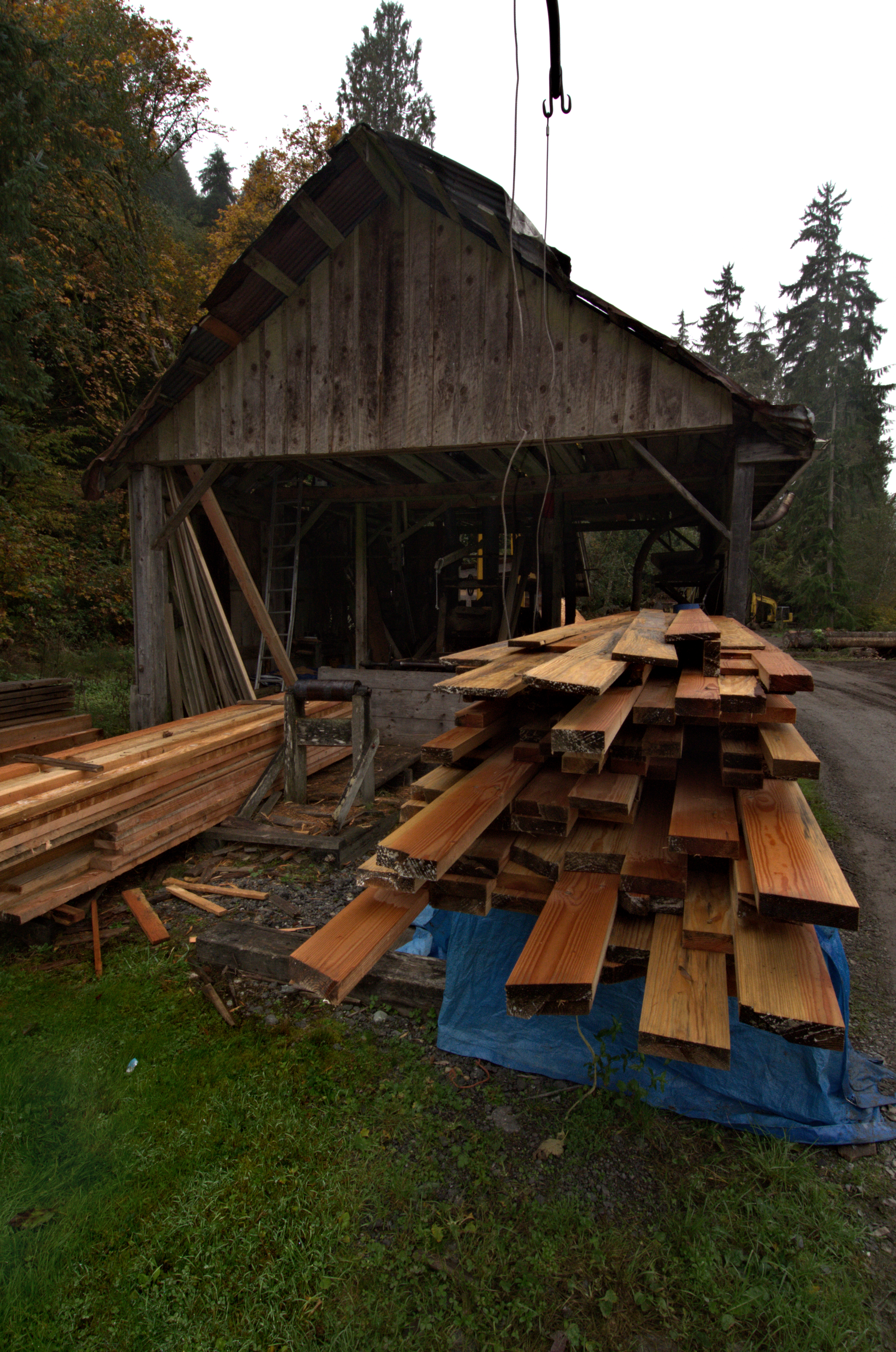
Isaakson’s Sawmill, Planer Building
Information Sources: The Sammamish Heritage Society and Duane Isaacson.
ICE STORM

Snow Tree Carillon Point, Kirkland, Washington
SeaTac International Airport has closed all three of their runways due to the ice thus stranding more than a thousand travelers. This just after an inordinate amount of snowfall for the region. There are power outages reported throughout the area.
I powered down my drivers’ side window to leave a layer of ice – it looked as if the window was still in the up position. Fun to show the neighbors how I can punch my “window” out!
Credit for Snow Tree Carillon Point to J. R. Hudson, Scenic Edge Photography
Sunset over the Pacific Northwest Friday, Januray 13, 2012

Pacific Northwest Sunset Friday January 13th, 2012
Tonight Pacific Northwest residents were treated by one spectacular sunset. Perhaps this is the most fantastic sunset I have ever seen in my lifetime. Each of the major television stations and newspapers featured submissions from area observers fortunate enough to have had cameras and cellphones with cameras with them today.
I took multiple images with my cellphone and stitched them together for a panorama to share.
-J. R. Hudson
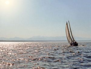
36 Foot Ketch on Puget Sound

36 Foot Ketch on Puget Sound
Before discussing the sailboat, worth identifying are the mountain peaks in the background. These peaks are the higher two peaks of the southern end of the Olympic Mountains of Washington State, a peninsula. First is Mount Ellinor, elevation 5,924 feet (1,805 meters), and to its right is a higher Mount Washington, elevation 6,259 feet (1,908 meters). I used these mountain peaks as an opportunity for a backdrop in order to achieve an enhanced composition for when a boat would pass by. I was rewarded when this beautiful twin-mast sailor with clipper-style hull indeed arrived! This boat, a beautiful sailing ketch, glided smoothly past on the sailing position known as a reach – with wind hitting its port beam. A number (“36”) clearly visible below the peak of the mainsail indicates the length the boat.
Beach Grass

Beach Grass
Who can forget those family trips from the inland to the coast if taken while a child if so fortunate? Not me. A world away from the gray concrete and mercury vapor lights which dominated Seattle and much of the surrounding area where I lived in the 50’s through 60’s, a trip to the flat-surf beaches of Washington State brought nothing short of an exotic change. Although local accommodations were sparse, little one-room cabins once populated the shoreline by the dunes. These were always a joy to spend summer days at.
These little cabins were never really clean by hotel standards, for example, if an oyster shell on a sill or in a shower and a thin film of sand on the floor are things you consider as inappropriate. Oh, but how appropriate! A few of these rough gems still exist from Long Beach at the southern end of the Washington Coast up to the edge of the Olympic National Park to the north. Names such as Grayland, Westport, Ocean Shores, Moclips, and Kalaloch were familiar to me when I was young.
“Beach Grass” was taken in the dunes along the Long Beach peninsula on Washington’s coastline. Roughly 20 miles long, The Long Beach Peninsula touts one of the longest continuous flat-sand beaches in the world. Indeed there is an archway that is inscribed with “The Longest Beach in the World”. This may be debatable, but it would take most people a full two days or longer to walk the length of the Long Beach Peninsula. Miles of soft sand and a couple of rocky headlands can stifle many from undertaking such an endeavor. The native grasses are very wheat-like.
Schooner Adventuress
We had a chance to witness the schooner Adventuress between Shaw and Lopez Islands in the San Juan Islands three weeks ago.

Rock Slide Mount Rainier
You would not have wanted to have been on Mount Rainier’s upper Nisqually Glacier last Saturday. Around 4pm a huge part of Nisqually Cleaver fell down creating a fast river of rock and snow. Witness this video:

This was on the south side of the mountain, however, witnesses claim to have seen the dust cloud from Seattle, farther to the north.
Carillon Point Marina – Spring

Tulips at Carillon Point
I took a break from work today at Carillon Point. I had to work a half day, but had to get out and walk along the waterfront at Carillon Point, the place which houses my office. These pictures share the ambiance I experienced there today.

Carillon Point Marina

Carillon Point Offices
